
Imagine getting in your car to go to work or drop your kids off at school, but you can’t even pull out of your driveway because your quiet, neighborhood street has become a congested freeway. Cars are lined up bumper-to-bumper; the tension is cut periodically by the sound of a horn honking.
Melissa Soesman doesn’t have to imagine. This Leonia, New Jersey, resident told the New York Times that her street becomes a parking lot during rush hour, and her son has been late to school as a result.
Melissa is not alone. Increasingly, this is reality for homeowners in small towns across America and throughout the world. Navigation apps like Waze and Google Maps are routing drivers from the heavy traffic on highways and arterials onto smaller neighborhood side streets, but these streets weren’t designed for the number of drivers they’re now receiving during peak travel times, and small towns are suffering the consequences.
Congestion and safety concerns on residential through-ways
Engineers collect traffic counts and make traffic volume projections when they design a roadway based on factors like population and land use (e.g. Is it a residential street or a commercial roadway lined with businesses that will attract people?) These traffic volume projections are used to make decisions about how many lanes a roadway needs, whether designated turn lanes or traffic signals are needed, and more. But navigation apps have rapidly increased the volume of traffic on many residential streets, and these streets were not designed for that level of traffic. As a result, they can’t move people as effectively as larger arterials can.
While navigation apps don’t create traffic (they merely move it from one place to another), some places are better equipped to accommodate high traffic volumes than others are. For example, left-turns can take a long time to execute because drivers must wait for an opening in both directions of traffic. If left-turns are commonly executed at an intersection, an engineer might design a designated turn lane for these drivers, so that traffic can still move freely for people going straight or making right-hand turns. But if turns were not common at the time the roadway was designed, it would not have a designated turn lane. A rush of drivers from a navigation app could cause severe delays on this roadway if they’re seeking to turn left in order to complete their route. Not only does the roadway have more traffic than usual, but the traffic pattern is not efficiently completed at this location.
Increased traffic volumes and higher speeds from pass-through drivers can reduce safety for residences on affected streets as well as people driving or crossing them.
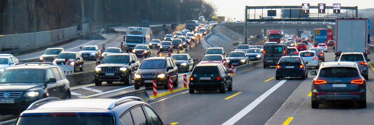
When traffic backs up on the highway, drivers turn to navigation apps for an alternate route.
Accidents and near-misses caused by out-of-town drivers unfamiliar with steep curves and blind spots on local roads
The traffic in Los Angeles is legendary, so it’s no surprise that drivers would rely on navigation apps to escape the congestion of its multi-lane highways. Some shortcuts are better than others, however. To navigation apps, Baxter Street looks like any other residential street, but it is very steep and you can’t even see oncoming traffic coming up the hill when you’re at the top. People who drive in this area every day are prepared for this sight distance issue when they turn onto Baxter Street, and they drive with appropriate caution. But people from outside the area who find the shortcut on an app have no idea what they’re about to encounter, and they often stop unexpectedly. Accidents have become increasingly common, according to an article in Spectrum magazine.
The problem is not unique to Los Angeles. Steep curves and blinds spots occur on every local roadway network. If a driver expects them and has driven through the area before, he or she can more safely navigate them, but these roads can be more dangerous when a driver doesn’t know what they’re about to encounter and can’t adjust in time. Unfamiliar drivers may approach a curve too quickly or stop suddenly when confronted with a blind spot. They may drive slower than other drivers as they try to navigate the tricky conditions, and opposing traffic may misjudge maneuvers because another driver’s actions don’t meet their expectations. All of this can increase the likelihood of accidents.
Heavy trucks tearing up the pavement (or making tight turns) on streets not designed to accommodate them
Trucks are bigger and heavier than cars. They create much more wear and tear on pavement than cars do, and they require a larger turning radius at intersections. Engineers take the volume of truck traffic on a particular roadway into account when they design the road for this reason. Roadways that see frequent truck traffic will be designed with a stronger and thicker pavement, and intersections will be widened to provide proper clearance for the trucks to navigate without encroaching on opposing traffic lanes.
The federal government has issued a maximum gross weight for individual vehicles of 80,000 pounds when traveling on federal highways. Pennsylvania has the same maximum weight limit, but many municipalities will post their streets for lesser weights because they know the roadway can’t handle the increased tonnage.
A study by the American Association of State Highway Transportation Officials (AASHTO) found that an 80,000 pound tractor trailer produces the same impact on pavement as 9,600 automobiles. This is exponentially larger than the weight differential between the two vehicles: The tractor trailer is only 20 times heavier than the average car (4,000 pounds), but its impact is almost 10,000 times greater!
As navigation apps route more and more trucks onto local roadways, those roadways will deteriorate faster. This means municipal officials will have to spend more money on pavement maintenance and replacement over time. They may be able to restrict truck traffic on local roads when certain conditions are met (such as deteriorating pavement or insufficient radii); however, this requires an engineering evaluation. This evaluation will cost money, and not every situation will warrant a truck restriction.
The biggest problem for borough officials is tight turns. Borough streets are typically older and narrower, and the intersections are not large enough to accommodate truck traffic. Truck drivers may cross over into opposing lanes as they try to execute the turn, risking impact with cars or forcing drivers in the other lane to back up in order to make room for the truck to get through. If they don’t cross into the other lane, they may come up onto the curb, damaging property.
This video, posted by regoTV on YouTube, shows how challenging it can be for trucks to navigate neighborhood streets.
These are growing problems in many towns across America, and communities have tried a variety of approaches to address them. Some communities have tried asking the apps to remove certain streets from their routing options, and frustrated residents have filed false reports of congestion to trick the app into routing people away from their homes. These approaches don’t work.
Realistically, communities are left with two choices:
- Improve the routes they want people to use, so congestion decreases (and people stay on the roads they’re supposed to take) OR
- Degrade the side roads and shortcut routes, so they become less desirable to app users.
Improving the routes takes time and money. Potential solutions include optimizing traffic signals or widening roads with extra lanes and added capacity, but this can cost thousands of dollars, and local governments struggle to come up with the funds.
Degrading the side roads is the most frequent tactic community leaders use because it is quick and relatively inexpensive. This includes:
- Lowering the speed limit
- Installing traffic calming devices like speed bumps (Learn more about traffic calming in our series)
- Closing roads at certain times of day or to certain drivers (who can provide proof of local residency through a permit)
Unfortunately these options inconvenience local residents and businesses as much as they inconvenience out-of-town drivers.
A long-term solution will require stakeholders from local municipalities and the state and federal government to work on public policy with the private sector companies operating the apps and researchers who are studying the issue at universities.
Real-time traffic apps don’t create or alleviate congestion; they merely move it from one place to another. Any solution that is attempted on a local level will merely move the problem a few miles further down the road.
You can read more about the solutions communities are trying, the research being conducted, and the legal implications of closing roads to certain drivers in the full article we published in the May 2020 issue of Borough News magazine, which is available only to print subscribers. (Or contact us for a copy.)
CONTACT US
HRG’s transportation team has been helping several municipalities address the challenges of traffic being re-routed by real-time navigation apps onto low-volume neighborhood roadways. Give us a call to discuss challenges your community is having